
MSU flight lab studies ag aviation patterns with eye toward UAS integration
Contact: Chris Bryant
STARKVILLE, Miss.—One hundred years after airplanes were first used in applying insecticide to crops, a Mississippi State flight lab seeks to understand how today’s agricultural aviators can safely share the skies with technology those early agriculturalists could not have imagined – unmanned aircraft systems.
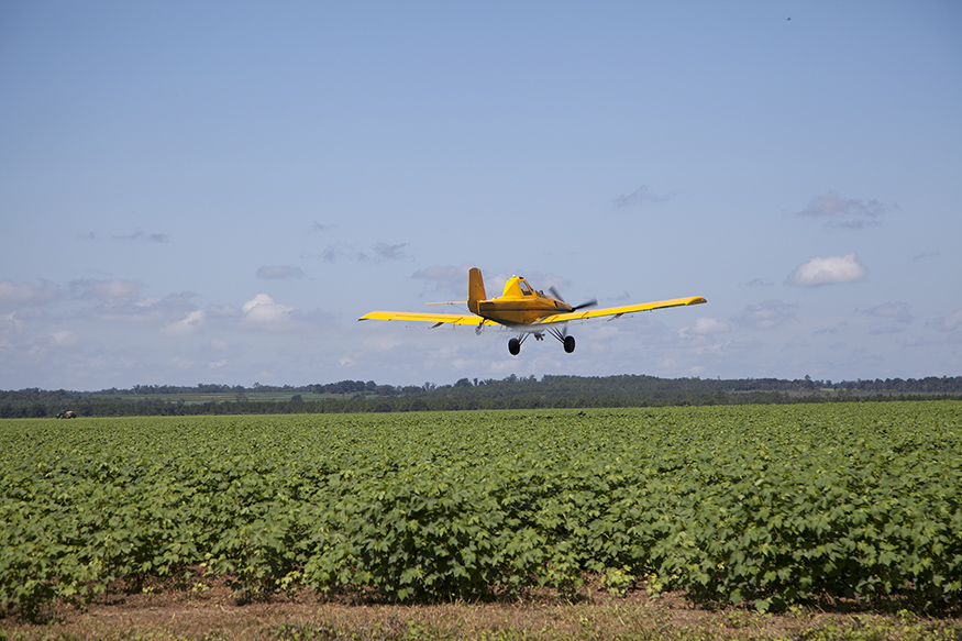
Agricultural aviators treat more than 125 million acres of U.S. cropland each year, according to the National Agricultural Aviation Association. Flying as low as 10 feet off the ground and at speeds up to 140 miles per hour, ag aviators share this low altitude space with unmanned aircraft systems, often referred to as UAS or drones, with greater frequency than other manned aircraft.
“With UAS increasingly populating the skies, it’s in everyone’s interest to better understand how these two types of aircraft can safely share airspace,” said Tom Brooks, director of MSU’s Raspet Flight Research Laboratory. “We’re synthesizing available agricultural aviation data to better understand typical flight patterns and tendencies of our ag fliers. We’re identifying trends and plan to later integrate this data with existing predictive models that will account for this vital aspect of aviation in developing safe integration of UAS into the national airspace system.”
With unmanned aircraft systems already aiding emergency officials with disaster relief operations, support for agricultural efforts, and environmental assessments, full integration into the national airspace system would enable UAS to safely and regularly operate in conjunction with manned aircraft during both emergency and non-emergency operations, while using many of the same air traffic management systems and procedures. By law, UAS must give the right-of-way to manned aircraft.
Agricultural aviation appears, in some ways, to be an understudied aspect of aviation, according to Raspet researchers. Topographical obstacles, the curvature of the earth and the positioning of radars at airport terminals, for example, limit radar-provided information on low-flying agricultural aircraft. A widely used national database provides radar information for flights as low as 1,000 feet, but many agricultural aviators spend much of their time at heights 500 feet and lower.
For its analysis, Raspet have drawn from some 35,000 individual flight data logs of ag aviators via the National Agricultural Aviation Association and the Mississippi Agricultural Aviation Association. Data from 20 states are included, and Raspet researchers have worked to analyze regional trends.
“Most of this low-altitude data is below what the major radar networks are able to cover,” said Kyle Ryker, a Raspet research engineer who co-leads the effort with Madison Dixon, a UAS program manager. “We can fill in some of these gaps.”
The data includes things like ag aircraft’s climb and descent rates, spray and cruise speeds and turning radii. Having a documented understanding of ag aviation operations can allow for better training of UAS operators who fly in rural areas and are more likely to encounter ag aviators, Dixon said.
“Aerial applications are labor intensive,” said Andrew D. Moore, National Agricultural Aviation Association CEO. “Ag pilots are looking for ground-affixed obstacles and trying to ensure precise, targeted applications, and studies have shown it is extremely difficult, if not impossible, for manned aircraft pilots to see UAS. The National Agricultural Aviation Association appreciates the MSU flight lab’s efforts to ensure the safety of manned agricultural aircraft as UAS traffic increases.”
As the project progresses and Raspet develops and refines its predictive computer models, follow-on efforts will begin integrating the datasets into widely used safety tools designed to predict air traffic densities and representative trajectories, Ryker said.
“Our work involves normalization of the ag aviator dataset to make it compatible with existing airspace characterization tools. This will ensure full visibility and awareness of this unique segment of aviation operations,” Ryker said.
Technological advancements in agriculture and aviation since the Aug. 3, 1921, flight to dispatch sphinx moth caterpillars from a Catalpa tree crop in Troy, Ohio, are nearly unimaginable, Brooks said.
“As a leader in both agricultural and UAS research, Mississippi State is well positioned to help each of these sectors understand the needs and concerns of the other and to provide regulators with the necessary data to ensure both groups excel,” Brooks said.
MSU’s Raspet Flight Research Laboratory is the nation’s leading academic research center dedicated exclusively to the advancement of unmanned aircraft systems. Raspet is the only institute in the world designated both as the FAA’s UAS Safety Research Facility and as official UAS Test Sites for both the FAA and the Department of Homeland Security. Home to a fleet of the largest and most capable unmanned aircraft in academic use, Raspet conducts UAS research on behalf of federal agencies and commercial industry alike, and it remains a world leader in composite materials research.
MSU is Mississippi’s leading university, available online at www.msstate.edu.